It is 6 AM, and you’re a traffic engineer in a medium-sized city with old-fashioned traffic infrastructure. A broken water pipe floods the intersection at Maple Street, blocking the flow in the two principal commute directions. What should he do now? Reroute the traffic downtown and destroy small businesses with the additional rush or reroute through the suburbs and close schools? The only thing is that he has no complete information; he knows just the city maps from thirty years ago.
Another situation in another part of the city. The city planner has decided to rebuild downtown, with mixed-use development, new transit links, bike lanes. He builds some scale models of the downtown, holds public hearings, makes some corrections based on it, and hopes that everything works out okay. The truth is that any corrections made during the reconstruction process increase costs by millions of dollars and prolong the time period.
So, we can conclude that it’s time for something more effective in urban planning. Urbanization processes continue, cities become more complex and interwoven, and decisions made nowadays will have an effect on future generations. But the instruments used by planners haven’t changed during half a century.
Now, the concept of digital twinning marks a radical transformation in the way cities can be planned, managed, and optimized. Digital twins of cities are living simulations of the urban environment that mimic the real-world conditions using data generated from thousands of sensors and connected devices. This is not a fancy simulation. This is an intelligent tool for decision making.
For cities that aspire to become smart—to be responsive, efficient, resilient, and sustainable—digital twinning is no longer just an innovative technology. It is a vital necessity.
The Urban Planning Crisis: Why Traditional Methods Don't Scale
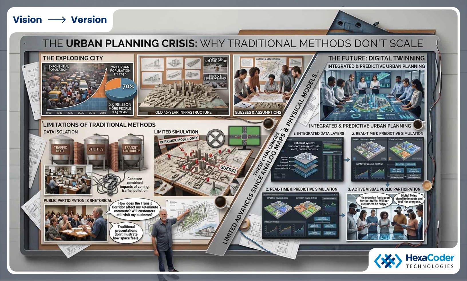
Cities are being bombarded today with challenges that traditional methods of planning can no longer cope with. Urban growth rates are rising sharply. By 2050, almost 70% of the world's population will be living in urban areas. This means 2.5 billion more people in cities in the next 25 years.
What does this mean? It means that the city planner who makes decisions now will basically make guesses about how the existing 30-year-old infrastructure system can deal with 30% more traffic, severe weather conditions, new patterns of mobility, and other changes. Traditional urban planning takes place under severe limitations.
Firstly, data isolation. The traffic division of the city has traffic data. The utilities company knows about water supply and energy infrastructure. The transit authority has its own databases. Park spaces, environmental quality, and air pollution—all of them are tracked separately, each by a separate department with its own format. It becomes impossible to get all the information necessary to see what impact a zoning change would have on traffic and how it, in turn, affects air pollution and public health problems.
Secondly, limited simulation. Urban planners can model a traffic corridor or analyze an individual development project, but modeling all the complex interrelationships of transport, zoning, utility services, climate, and human behavior is beyond today's technology. The city makes the decision to convert parking into green space in the downtown area. However, without integrated simulation, no one will know how it impacts the traffic flow in neighboring areas, transit usage, and how the business performs. The decision is made based on assumptions, precedents, and not data.
Thirdly, public participation is still mostly rhetorical. Public consultations take place when the residents view images and floor plans of future projects. But can the resident-commuter figure out how the transit corridor impacts their daily 40 minutes commute to work? Or the business owner visualize how customer flows would look like in the redesigned streetscape? Traditional representations cannot fully illustrate what a space feels like.
These are the challenges facing modern cities today. The complexity of decisions is higher than ever before, and yet there have been few advances in decision-making technology since the time of analog maps and physical models. This is where digital twinning comes in.
What a Digital Twin Actually Is: Beyond the Buzz
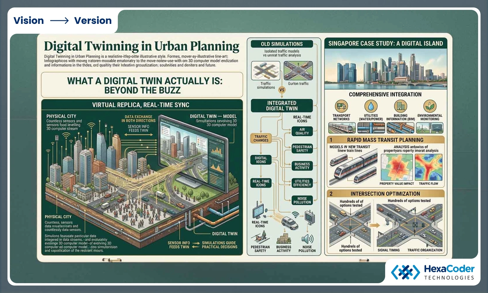
Although digital twinning is considered future technology, in essence, this technology refers to creating a virtual replica of a real-life system which constantly takes in information about the latter and processes it in order to simulate various scenarios based on facts.
In the case of a city, a digital twin would be an evolving 3D simulation incorporating various datasets such as the physical structure of the city itself (its buildings and infrastructure), sensor information like air and noise pollution, traffic flows, water pressure; the dynamics of human life (their movement and activities), and the utility systems (electricity, water distribution, waste management).
Data exchange happens in both directions as well. Information gathered by sensors in the real-life city will be fed into its twin. Simulations conducted there will provide valuable insight for making practical decisions in the real city.
This is where the essential distinction between previous simulation methods and what we're talking about comes into play—integration and real-time capacity. It isn't about simulating traffic flow. It's about understanding the interconnection between traffic changes and effects on air quality, business activity, public transport passengers' numbers, pedestrian safety, and noise pollution at the same time. Real-time means that the twin is constantly synced up to the actual conditions since the input information is updated continually.
Singapore provides an excellent case study here. The country created a comprehensive digital twin of its island integrating transport networks, utilities, building information, and environmental monitoring systems. In doing so, Singapore was able to test out rapid mass transit systems, evaluate the impact they'd have on property prices and traffic, and plan their deployment strategically without spending any money. To evaluate the changes necessary to make one of its intersections function better, they simulated hundreds of options for changes in signal timing and traffic organization.
The Practical Benefits: When Digital Twins Solve Real Problems
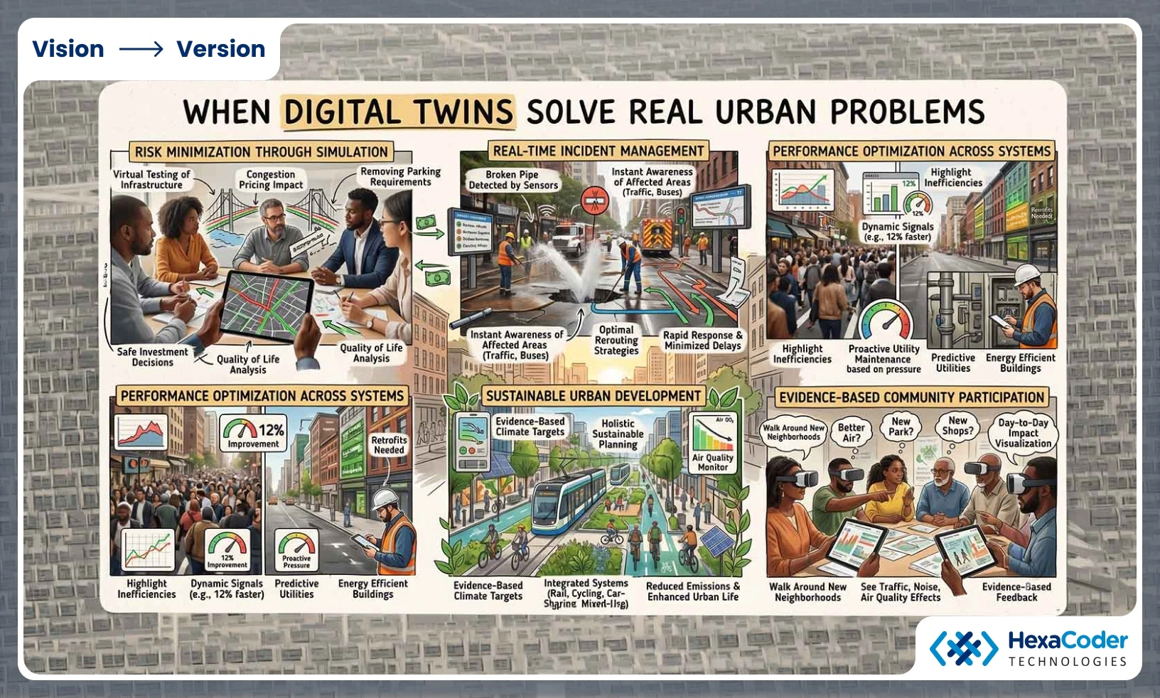
The benefit of digital twinning comes into clear focus when considering its capabilities.
Minimization of risk by way of simulation.
Before spending millions on an ambitious piece of infrastructure development, a municipality can perform a virtual simulation of said development. What will happen if congestion pricing is instituted? Where will the traffic divert, and are there sufficient resources available in surrounding neighborhoods? If we were to scrap the parking requirements for new apartments in the central part of the city, how would this change affect business and pedestrian traffic? All of these decisions carry massive monetary implications, as well as implications for quality of life. They're made safe by way of simulation.
Real-time incident management.
The scenario with the bursting of a water main becomes less daunting with digital twinning capability. As soon as the sensor on the infrastructure picks up on the failure, the twin understands that it affects traffic patterns, bus routes, etc., and offers a solution for optimal rerouting based on the present state of affairs.
Optimization of performance across systems.
A digital twin analyzes the performance of the city and highlights inefficiencies. The road network between the stadium and the city experiences traffic jams, while a parallel road is underused. Testing a dynamic signal timing improvement strategy in the digital twin indicates that it will improve the average travel time by 12%. This optimization strategy is adopted. A utility company detects unusual pressure readings in a pipeline, which may lead to failures several weeks before any breakage occurs. Instead of acting reactively, it plans its maintenance proactively. Energy consumption trends indicate inefficient operations within buildings, thus requiring retrofits.
Urban development sustainably.
Cities are faced with massive pressures to meet their climate targets despite growing populations. Through digital twins that incorporate environmental data, cities can plan sustainably based on evidence. If a city aims to minimize emissions from vehicles, it can test the impact of introducing new rail services, car-sharing programs, cycling lanes, and zoning to promote mixed-used development. But not only in isolation but as a comprehensive system. What will reduce carbon emissions while enhancing urban life? The digital twin demonstrates this possibility.
Evidence-based community participation.
As changes to a city occur, the community wishes to see what effect this will have on their environment. With a digital twin, you can visualize much more than just renderings. Walk around the new neighborhood and see how it really affects your day-to-day existence based on traffic, noise pollution, quality of air, pedestrians, and economic activity.
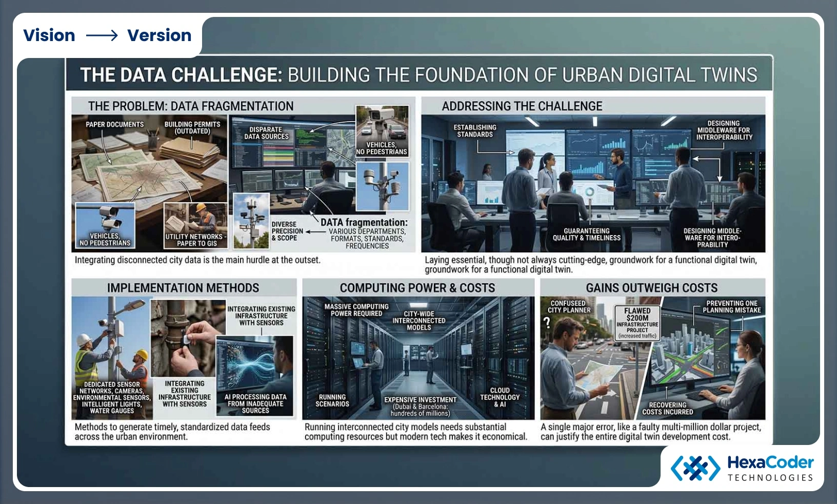
The Data Challenge: Building the Foundation
The concept of digital twins seems impressive, but developing one faces practical difficulties at the outset. The main problem is data integration.
Urban environments feature disparate data sources managed by various city departments, using different formats, standards, and frequencies. Data on vehicles collected by traffic cameras may not include pedestrian flows. Building permits can be up-to-date or outdated. Utility networks vary from paper documents to GIS databases. Environmental sensors come with diverse precision and scope.
To make a functioning digital twin, the problems of data fragmentation need to be addressed. This involves establishing standards, guaranteeing quality and timeliness, and designing middleware for interoperability. These may not be cutting-edge technological solutions, but they are crucial.
Several methods are being developed. Cities are installing dedicated sensor networks for the digital twin, including cameras, environmental sensors, intelligent traffic lights, and water pressure gauges, providing standardized and timely data feeds. Cities can integrate their existing infrastructure with sensors. Some are implementing AI to process data from inadequate sources.
Computing power is a must. Running many scenarios using an interconnected model for the entire city will need a lot of computing power. With cloud technology and growing AI capabilities, it is possible to make it economical, but it is still expensive. Dubai and Barcelona, cities that have made investments in building a smart city ecosystem, mention the costs in the hundreds of millions of dollars.
However, the gains outweigh the costs. A single mistake in planning an infrastructure project worth, for instance, $200 million that does not reduce traffic but increases it is enough to recover the costs incurred in developing a digital twin ecosystem.
The Strategic Imperative: First-Mover Advantages
The use of digital twins creates structural advantages. Some of the key structural advantages for cities using digital twins include:
Data advantage.
Cities that invest in data integration and creating baseline information for decision making benefit from a better understanding of complex interplay of factors. Only during long-term use and analysis do patterns emerge that cannot be identified on one-year snapshots.
Decisional advantage.
Decision-makers who work within a digital twin approach develop better intuition on how urban systems work and how they inter-relate. They learn to play out radical scenarios and gain experience from modeling. Decision-making culture moves away from risk aversion leading to inertia towards experimental thinking based on evidence.
Resilience advantage.
Cities that use digital twins will have a greater degree of insight into how urban systems function and what kind of actions may lead to improved performance and resilience. Climate change will require cities to respond to rising frequency of floods and extreme weather. Cities with digital twinning infrastructure are better equipped for resilience planning and emergency responses.
Talent advantage.
Cities known to be innovation leaders in urban technologies are attractive destinations for specialists – planners, technologists and entrepreneurs.
The Realistic Path Forward: Implementation Challenges
While digital twinning is a very potent technology, implementing it has several barriers.
First, departmental silos in cities remain. Departments, used to operating independently for decades, find it difficult to integrate. Why is this so? Control, budgetary considerations, institutional identity, and technical difficulties related to data governance.
Second, budgets are tight. City managers face immediate issues such as road repairs and emergency response. Allocating funds amounting to hundreds of millions of dollars to technological infrastructure seems like an unnecessary luxury before its benefits are clear.
Third, qualified personnel are rare. Urban planners usually receive no specific training in digital twinning and its governance. This means that cities wishing to implement the technology must train or hire relevant personnel. Neither is a cheap option.
Fourth, the technology itself faces limitations. Although the underlying concepts have been verified, the tools required for implementation are relatively new and still developing. Early adopters therefore run a risk of using technologies which may prove obsolete in the future.
Nevertheless, the trend towards adopting digital twinning is rapidly gaining pace. It is estimated that by 2025 over 500 digital twins of cities will be implemented worldwide.
The Future City: What Success Looks Like
In a city where digital twins have already been established, urban planning becomes an entirely different process.
The mayor is concerned about housing costs. Instead of talking about zoning laws, planners will run a simulation for the entire situation: rezone areas for higher density, see what happens with the roads and traffic, what transit upgrades are necessary to serve the influx of residents, cost of construction overall, and predicted value and tax revenue. Consider the effect on air pollution levels, park usage, and general aesthetics. Do the test multiple times with varying factors. Now they go back to the people with proven solutions, not guesses.
The utility company knows that their infrastructure is in desperate need of upgrading. They will use information from the digital twin to pinpoint the exact areas at risk for failure according to age, location, type of soil in which it lies, etc.
The public transport authority wants to enhance its bus services. It is not about estimating needs through past trends. Rather, it models changes in mobility requirements driven by current zoning changes, housing development, and job creation. The service is provided where it is needed.
The city anticipates a 100-year flood event. It is not about responding to the disaster without understanding what happened. The city simulates evacuation plans, hospital capacity, power grid weaknesses, and supply chain breakdowns. The city knows where help is more likely to be needed.
This is not fiction. This is the reality offered by digital twins implemented in advanced cities.
The Planning Imperative
Planning has always involved decision-making with incomplete information. Urban planning is inherently a process of making bets that the planner hopes pays off. But in an era of increasing complexity, density, and interconnectivity, cities cannot afford to continue to rely upon traditional planning methodologies. This is both inefficient and irresponsible.
It's time for cities to begin planning for their future by leveraging advanced computational technologies to visualize, understand, plan, design, and execute at scale in real-time. Cities capable of doing so will succeed. They will be able to attract talent and investment. They will be resilient in the face of crisis, able to manage their systems proactively, and optimize them continuously without waiting for a crisis to prompt change.
Cities unable to see and understand the true nature of their systems through digital twins will be forever hamstrung by the limits of twentieth century planning technology and methodology in the realities of a twenty-first century world.
The future of urban planning is not in the visionary minds of planners. Rather, it is in the ability to see cities' systems clearly and act rationally on that vision through digital twins. The question is no longer if, but how soon can cities transition to a digital twinning model.
For another view of interactive visualization, read our car configurator companies guide and our 3D product configurator comparison.