Hi there 👋

Start having a chat with our AI Bot. Let us know what you're up to and connect with our team in a day.

Start growing your business with us

Select an option
Smart Point Cloud Solutions

Turn raw 3D scan data into actionable intelligence

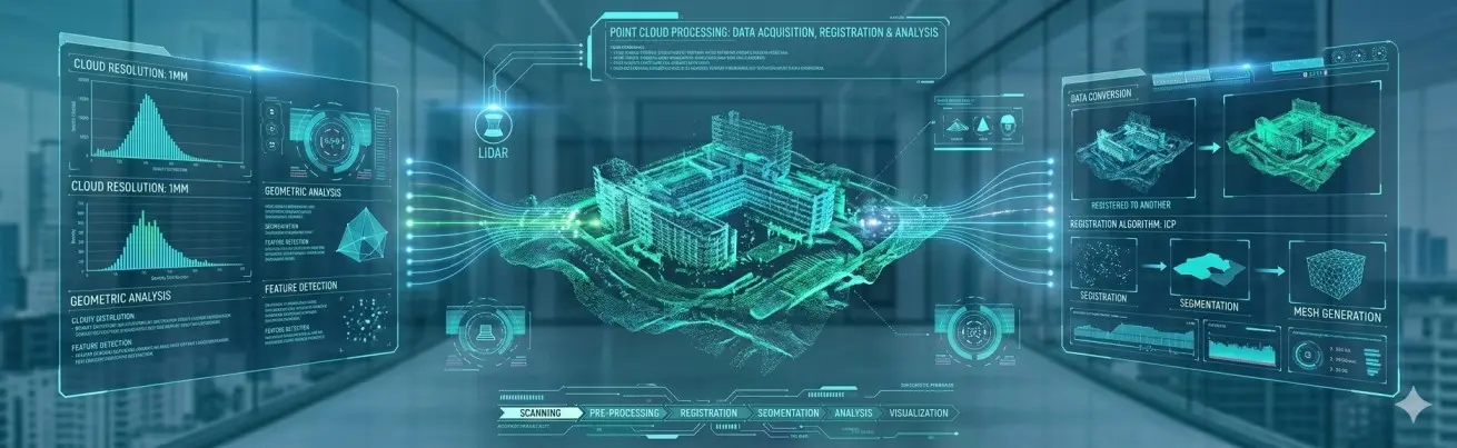
with high-quality Point Cloud Processing by HexaCoder Technologies. Complex 3D point cloud data is fully realized and converted into models for Digital Twin technology, AR/VR environments, geospatial workflows, and enterprise-level digital transformation solutions. The experts delivering such 3D data processing services are also skilled at consulting, seamless data integration, and producing high-precision outputs which businesses can use to make smart decisions with considerable confidence.

POINT CLOUD DATA
3D SCANNING
DATA PROCESSING
CLOUD REGISTRATION
POINT CLOUD SEGMENTATION
3D MODELING SERVICES
LiDAR PROCESSING
DIGITAL TWIN CREATION
SPATIAL DATA ANALYSIS
REALITY CAPTURE
Point Cloud Processing Banner
0%
Improves accuracy by converting raw scans into detailed 3D models.
0%
Speeds up project delivery through automated data processing workflows.
0%
Enhances asset management by enabling precise digital twins creation.
0%
Reduces field survey costs with efficient remote data capture and analysis.

Check out the Smart Packaging Transformation Guide

0%

Conversion lift

An all-encompassing AI-powered packaging solution for next-gen print businesses

Our Way to Success in Point Cloud Processing

Straightforward and Precise 3D Data Processing Workflow

Data Acquisition & Preparation

Data Acquisition & Preparation

We brought precision to all incoming 3D point cloud data-cleaning, formatting, and preparing raw scans for seamless processing. This fundamental phase guarantees dependable results for all digital transformation applications.

Advanced Processing Techniques

Advanced Processing Techniques

Advanced point cloud registration, noise removal, and structural identification techniques help extract significant spatial insights using cutting-edge algorithms, AI-assisted filtering, and intelligent segmentation.

Customized Deliverables

Customized Deliverables

We make offerings to suit your requirements- 3D models, engineering reports, digital twin files, AR/VR-ready assets, or architectural visualizations-matched with your business objectives and industry workflows.

Quality Assurance & Validation

Quality Assurance & Validation

Once again, every dataset is subjected to stringent QA checks. Accuracy, consistency, and structural integrity are all validated by our experts to produce high-quality results in 3D data processing for reliable decision-making.

Transforming Raw Data into Actionable Insights

Comprehensive AR Product Visualization Services for Enhanced Shopping Confidence

Our comprehensive point cloud processing services empower businesses to extract valuable information, visualize complex environments, and make data-driven decisions.

Hire Our Experts for Advanced Point Cloud Processing and Data Visualization
Precise Registration
We accurately align multiple scans into a unified and coherent point cloud, eliminating discrepancies and ensuring a complete spatial representation for reliable analysis.
Intelligent Segmentation
Our advanced techniques allow for the automatic or semi-automatic identification and isolation of specific objects or features within the 3D data, enabling focused analysis.
Detailed 3D Modeling
We create accurate and detailed 3D models from point clouds, providing realistic representations for visualization, simulation, and design purposes across various applications.
Advanced Analysis & Reporting
We go beyond basic processing, offering in-depth analysis, measurement extraction, and insightful reports to support informed decision-making based on your spatial data.
Data Optimization & Management
We optimize and manage large point cloud datasets for efficient storage, retrieval, and utilization, ensuring seamless integration with your existing systems and workflows.
Integration with Digital Platforms
Our processed point cloud data can be seamlessly integrated with various digital platforms, including BIM, GIS, and other industry-specific software, enhancing collaboration and data utilization.
Solutions at Every Level

Our Available Solutions

Cost-Effective Point Cloud ProcessingQuick Prototype VisualizationSpatial Understanding for Innovative Solutions

Startup Solutions

For startups exploring 3D technology, we offer cost-effective point cloud processing to quickly visualize prototypes and gain spatial understanding for innovative solutions.

Accurate Asset ManagementSite Surveys & Progress MonitoringCost Savings Through Operational Efficiency

Business Solutions

Businesses can leverage our point cloud processing to improve operational efficiency through accurate asset management, site surveys, and progress monitoring, leading to significant cost savings.

Scalable Point Cloud ProcessingDigital Twins & Large-Scale Infrastructure ManagementAdvanced Spatial AnalyticsHigh-Quality 3D RenderingMulti-Device & Cloud-Based ARERP & Supply Chain IntegrationEnterprise-Grade Security & ComplianceCustom AR Innovation & Consulting

Enterprise Solutions

Enterprises benefit from our scalable point cloud processing for complex projects, including digital twins, large-scale infrastructure management, and advanced spatial analytics across their operations.

Enterprise 3d Software Company
4.6
Enterprise Product Configurator Company
4.7
Enterprise Digital Twin Software Company
4.7
3d Product Configurator Development Company
100%
Global Brands Adopting 3D Configurators
Toyota Alsayer
PLC
Vitkonwood
Harley-Davidson
Nike
Rolex
Corporate background with abstract shapes
Turning Raw Data into Actionable Insight

Hire Our Experts for Advanced Point Cloud Processing & Data Visualization

Our Point Cloud Processing services enable creation of visual realities through which enterprises can understand complex structures and help drive data-centric digital transformation.

Straight Registration

We accurately register and merge multiple LiDAR or photogrammetry scans into high-fidelity point cloud data within a single complete dataset to create spatial accuracy, eliminate registration faults, and allow appropriate engineering, surveying, and Digital Twin viability analysis.

Intelligent Segmentation

Our automated and semi-automated techniques are used to provide identification, separation, and classification of items within dense three-dimensional point clouds, thereby allowing focused analysis and facilitating streamlined geospatial workflows while enhancing automation in industries dependent on object detection, structural mapping, and environment understanding.

Detailed 3D Modelling

This is concerning changing complicated point cloud data into detailed, exact 3D models that are applicable to design, simulation, planning, AR/VR, and Digital Twin. Each model has been optimized to ensure accuracy for better visualization as well as improved decision-making and engineering workflows across diversified industries.

Advanced Analysis & Reporting

We deliver deepest technical insights by measurements, spatial analytics, deviation checks, and reporting. For example, inspections, asset management, structural assessments, and engineering decisions based on accurate, data-driven intelligence will leverage this analysis from your point cloud datasets.

Data Optimization & Management

Massive datasets, referring to point clouds, have started making hassle-free processing possible. It will take very few efforts to get rid of unnecessary noise, optimize file sizes, and restructure data use distribution. All these factors will quickly increase processing speeds and simplify performing actions, storage, and flow in already implemented, long-term digital transformation workflow.

Integrated with Digital Platforms

Our processed point clouds integrate into BIM, GIS, CAD, and Digital Twin platforms effortlessly. Such connectivity is thus assured for an enhanced collaborative environment and aligned data flow and unified digital operations across architecture, construction, manufacturing, and enterprise ecosystems.

We are available now

Partner with Our Point Cloud Processing Experts

Ready to leverage the power of point cloud data? Hire our skilled developers to unlock valuable insights and drive your digital transformation initiatives.

Explore Our Portfolio

A showcase of the ideas I've brought to life — from concept to execution. My portfolio reflects my passion for design, technology, and storytelling, blending creativity with functionality.

Why Choose HexaCoder for Point Cloud Processing?

We have several years of experience in processing accurate and high-value, 3D data intelligence across diverse industries for application in Advanced Point Cloud Solutions, geospatial data processing, Digital Twin workflows, and AR/VR applications.

logo

Cutting-Edge Technologies for 3D Configurator Development

We leverage the latest technologies to deliver exceptional 3D configurator solutions.

CLIENT TESTIMONIALS

Real Results. Real Client Impact.

Your Digital Door is Open! Step Inside
Experience Excellence with Leading Solutions
Let's Explore
FAQs

Your Questions, Answered

LiDAR scans, photogrammetry outputs, and datasets acquired using a drone, terrestrial laser scan, or mobile mapping are some examples-of-the-most-advanced input data point cloud processing accepts. It also includes depth camera inputs, other standard point cloud formats like LAS, LAZ, PLY, and XYZ, E57, and PCD.

© Copyright 2026 Hexacoder Technologies. All rights reserved.

DMCA.com Protection Status